Featured
Agency responsible for irrigation and flood control in Middle Rio Grande looks toward its next 100 years


Published
Modified
The Middle Rio Grande Conservancy District has been preventing floods, providing drainage and releasing irrigation waters for 100 years. Facing a future with increased urbanization, lighter snowpacks and heavier monsoons, MRGCD is focused on strategies to keep agricultural traditions alive.
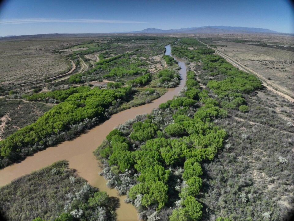
The Rio Grande’s flows have been shaped by human intervention.
With drains, canals and dams, entities like MRGCD, the Bureau of Reclamation and the Army Corps of Engineers have made the river’s flow more predictable, reducing flood risk and ensuring the river could run without drying through Albuquerque for most of the year. The levee system has also reduced the width of the Rio Grande’s flooding, creating a continuous cottonwood forest within the Rio Grande Valley State Park.
“When the district was formed, one of their primary problems was flooding,” said Jason Casuga, MRGCD chief executive officer. “We find ourselves now in a period of time of extreme drought, water scarcity.”

Approximately 84% of New Mexico is in some state of drought, with 38% of the state in extreme drought and almost 10% in the most drastic state of exceptional drought.
Mountain snows act as a natural reservoir for water, feeding rivers as snow melts in spring and summer. Since the 1950s, snowpack has been decreasing in New Mexico, as well as in Colorado, Utah and Wyoming where the headwaters for the Rio Grande, San Juan, Colorado and Navajo rivers are located, according to a report from the U.S. Environmental Protection Agency.
Snowpack and snowpack runoff are projected to decline substantially by 2070, while average temperatures in the state are expected to increase 5 to 7 degrees over the next 50 years, making the state more arid, according to a 2022 report from the New Mexico Bureau of Geology and Mineral Resources.
In 1925, there were more than 70 acequia diversions off the Rio Grande from the area where Cochiti Dam was later built to the San Acacia Reach. MRGCD was created to replace that system, consolidating down to four diversions and focusing on equitably sharing water from north to south. It owns canals and levees across four counties, as well as land adjacent to the river, like Albuquerque’s bosque.
MRGCD is funded by tax dollars from people who own property within the district and benefit from it. It is run by an elected board and the next election will be in October. The board holds monthly meetings, and much like a city council or school board meeting, the public can attend and weigh in.
For interagency decisions and debates on water management, which usually involve federal heavyweights like the Bureau of Reclamation or the Department of the Interior, being locally and democratically run sometimes makes MRGCD the government agency in the room with the most direct relationship to the people it serves.


A new hydrological reality

One of the wettest periods on record for New Mexico was the 1980s and 1990s. Water was spilling out of reservoirs like Elephant Butte, Casuga said.
The Natural Resources Conservation Service recently published a revised 30-year average for snowpack conditions, and across the board the average is much lower than it was for the previous 30-year period, according to Anne Marken, MRGCD’s river operations and telemetry manager. As temperatures rise, even in years when there is an average snowpack, less of that water ends up in the river. Higher temperatures also cause higher depletions within the river.
The irrigation system in New Mexico is driven by snowmelt. In the spring, when snow melts in the mountains and rushes down the Rio Grande, there is typically more water in the river than Middle Rio Grande Valley farmers need. So MRGCD would hold some of that spring pulse at El Vado Dam or Abiquiu Lake. As the supply of water begins to dwindle, MRGCD would begin to release water to augment farmers’ supply.
“There are a lot of forecasts that show that we’ll probably be getting a similar amount of precipitation in the year, but a lot of that will be shifting to monsoon events in the summer, and we have seen an uptick in some very high-intensity rain events in the summer,” Marken said. “So we are also thinking proactively about, ‘How can we shift our infrastructure to be prepared for that potential shift in how we receive precipitation?’ Because the way we’re currently set up is to capitalize on that snowmelt runoff, and in the future, the opportunities might be elsewhere.”
Long term, that change in weather patterns could call for new reservoirs in different locations and the ability to store water within channels, so if rain comes in after irrigation water has been released, the released water could be temporarily held in the channel, Marken said.
Monsoons also deposit more sediment into the river than snowpack runoff, which is slower and less intense. So MRGCD will likely need to manage increased sediment in the Rio Grande, said Casey Ish, MRGCD’s conservation program and special projects manager.
Rio Grande Compact
New Mexico has a water debt of 124,000 acre-feet through the Rio Grande Compact, a legal agreement that shapes water management along the river. Signed in 1938, the compact is an agreement between Colorado, New Mexico and Texas about how to share water, and it looms over MRGCD’s day-to-day work. When New Mexico is 200,000 acre-feet in debt, the state has violated the agreement.

Unlike some other water-sharing agreements in the West, the compact does not dictate a set amount of water has to be sent along the river each year. Instead, the states’ have to deliver a percentage of the water in the river system to their downstream neighbor. The percentage is larger in wet years and smaller in dry years.
“We try to characterize how much water the farmers need, and make sure we’re not diverting more,” Marken said. “While we’re balancing what the farmers need, we’re also looking at environmental species’ needs, and also Rio Grande Compact compliance. So we’re always balancing all these competing uses for this water.”
Endangered species like the silvery minnow and willow flycatcher are protected by the Endangered Species Act, at times mandating that water be used to boost their survival.
This May, the decision of whether to store water or release it is an easy one, because legally at this moment, New Mexico can’t store native Rio Grande water for non-Pueblo use, because New Mexico owes too much water to Texas to store any for itself. The pueblos have older water rights, giving them priority.
New Mexico’s current compact debt began in 2019. The following year, there was not much snowpack and not many monsoons, so the stored water New Mexico had was quickly gone, Marken said. But the state was holding a store of water for Texas — 30,000 acre-feet — to meet its compact obligations.

Water managers in New Mexico asked Texas officials if that earmarked water could be used in the Middle Rio Grande Valley. Texas said yes, further growing the compact debt. In subsequent years, the debt has crept higher.
This lack of storage ability creates uncertainty for irrigators about how much water will be available. Typically, the natural summer inflows are not enough to meet farmers’ needs, making them reliant on monsoon events, Marken said.
In the spring, farmers are trying to make planting decisions based on water availability in the summer, but when storage is unavailable, it makes predicting what to plant more challenging.
To improve its operations, MRGCD is exploring a new way of operating, where it evaluates compact delivery on a month-to-month scale to ensure it’s not falling behind on water delivery, Marken said, something Colorado already does.
The rules around who gets what water from the Rio Grande could shift in the coming years. There is ongoing litigation around the Rio Grande Compact because of past compact violations by New Mexico. The states came to a settlement agreement, but the federal government objected, so settlement discussions are ongoing.
Within the next 100 years, Casuga expects an Indian water rights settlement for the six Middle Rio Grande Pueblos, which would likely come with an adjudication of water in the Middle Rio Grande Valley, a legal determination of exactly how much water belongs to whom.
“That’ll change the dynamic in the middle valley, but it’ll also bring surety to priority of water and what those priorities are in terms of how much there is, whose it is, and what the priority of that is, which I think is important,” Casuga said.
The pueblos’ prior and paramount water rights were recognized by the U.S. government in the early 1900s. In 2022, the six pueblos started a legal process for the formal determination of water rights in the Middle Rio Grande.
Urbanization
As a new Interstate 25 interchange is being built near Tomé, and Los Lunas sees an influx of new residents and big investments from companies like Facebook, Valencia County is likely to become more urban. Bernalillo County is also likely to continue increasing density in its existing urban areas.

To promote agriculture and green space within the valley, MRGCD’s elected board has directed Casuga to protest if someone is trying to transfer water from within the valley to an area outside the district, said MRGCD Board Member Stephanie Russo Baca.
When someone is trying to take water outside the district, it is generally related to municipal development and private residential development, said Technical Services Director Eric Zamora. If someone is adding a subdivision within a municipality, the municipality will typically require the developer to prove they have enough water rights for the subdivision.
MRGCD will play a role in maintaining the agricultural character of Valencia County and be an advocate for Albuquerque’s agriculture by supporting policies to protect green spaces, Casuga said.
“Let’s make good subdivision standard decisions on how dense we’re going to make the places right along the river and in the green spaces,” Casuga said.
Cathy Cook covers the federal government for the Albuquerque Journal. Reach her via email at ccook@abqjournal.com.


